
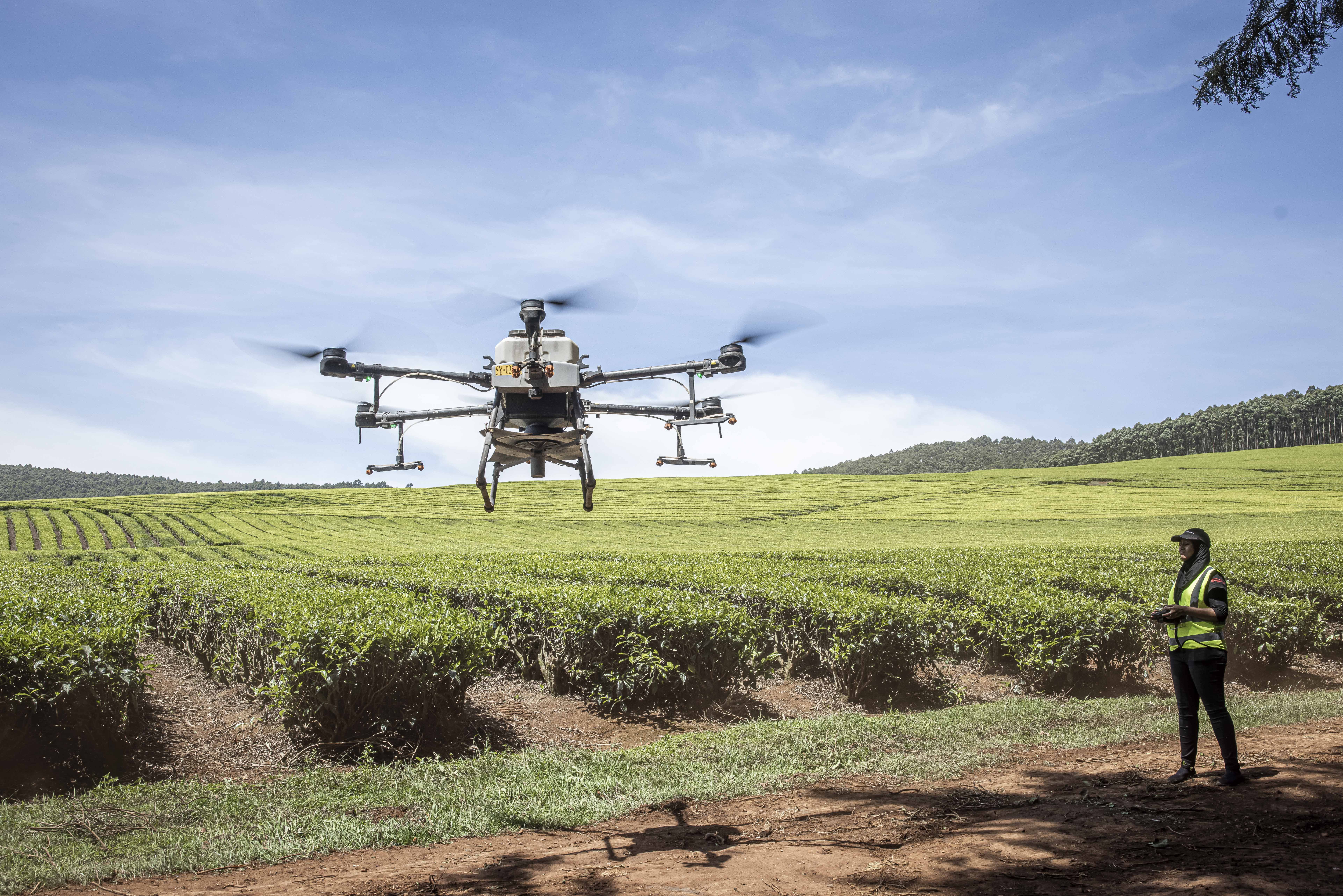
In Kamonyi District in Rwanda, the buzz of drones has become a familiar sound. Local start-up Ampere Vision Rwanda is seeking to pioneer agricultural drone services; its quadcopter hovers over the 130 hectares farmed by the Koubite cooperative, gently spraying fertilisers and pesticides onto the crops below.
The efficiency of drones is a game changer in an industry where time is money. “With the drone you can do 21 hectares in just one day,” says Muyombano Happy Axel, the company’s founder. “If you are going to use a boom stick, it’s going to take you three or four days.”
Ampere Vision Rwanda is at the start of its journey. It has recently received a grant of 15m Rwandan francs ($10,000) from non-profit Heifer International, as it seeks to expand its services to a wider range of cooperatives in Rwanda. The company is one of many in Africa that is seeking to make use of drone technology to transform how various industries operate.
Peaceful purposes
While “unmanned aerial vehicles” (UAVs) have recently been in the spotlight due to their role in conflicts around the world, drone technology is increasingly being used for peaceful purposes in Africa. As well as spraying crops, drones are monitoring energy installations, delivering medicines, cleaning buildings, conducting mineral exploration and carrying out high-resolution mapping.
Yet the continent still has a long way to go to fully realise the potential of the technology.
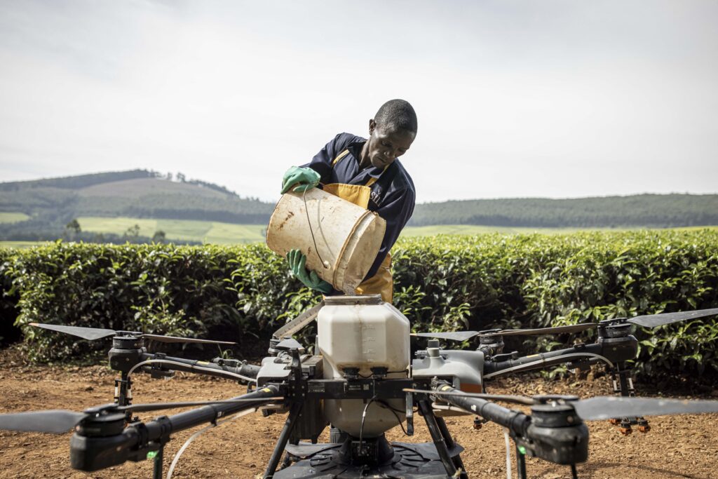
On South Africa’s massive commercial farms, drones are competing not with hand-held boom sprayers, but with tractors and crop-dusting planes.
Dexter Tangocci, founding director at South African drone services company Integrated Aerial Systems, says drones are becoming more and more competitive as the technology improves.
“Drones have gotten bigger,” he says. “We started with 10 litres. We now are on to 100-litre capacity drones, and 200 litres will be hitting the markets in the not-too-distant future.”
Larger drones will narrow the gap with human-piloted aircraft in terms of the area they can cover, Tangocci says. Meanwhile, they offer an “improved application quality”. Drones fly lower, meaning chemical inputs can be applied more accurately with less waste than when using human-piloted aircraft, he says. Drones also have an advantage over boom sprayers mounted on tractors, Tangocci adds. When tractors turn in fields, they run over crops, typically causing losses of 3% to 8%. By flying overhead, drones avoid this problem entirely.
Tangocci says the next step will be to equip drones with multi-spectral cameras that collect information on plant health with the help of artificial intelligence. The drones can then apply chemical inputs in a more targeted manner.
Combining drone crop surveillance with the applications of chemicals and fertilisers “can get very interesting for the South African market” says Tangocci. “We are confident from the outset that we can save up to 30% of those chemicals and fertilisers by conducting a survey and then applying with a crop-spraying drone those chemicals and fertilisers that need to be applied.”
Infrastructure surveillance
Another key use for drones in Africa is in inspecting hard-to-reach infrastructure, using high-resolution cameras to detect faults.
Integrated Aerial Systems, for example, offers its services to wind energy companies. “With wind, your turbines are 120 metres up in the air,” says Tangocci. “And those turbines just keep getting higher and higher.” In the past, companies would use cranes or rope access to inspect turbine blades – a highly time-consuming process that carries obvious safety risks. “Drones, very quickly in the wind space, became the logical conclusion for inspections.”
“We fly on very precise flight paths, between 7 and 10 metres from the blade, and with a very high-resolution camera, with a zoom lens,” says Tangocci. “You can look at the most minute details and categorise anomalies into your maintenance plan.”
Drones can complete an inspection of an average-sized wind farm with 46 turbines in as little as five days, Tangocci says, bringing a “much higher level of detail and speed”.
Another company that provides drone-based inspection services is Ghanaian firm Skyway Aero Group. Its drones are used for monitoring various types of energy infrastructure, including pylon-mounted power cables that stretch across vast distances.
Kwamena Hazel, Skyway Aero’s CEO, says energy companies previously patrolled over thousands of kilometres on foot and by car to assess the state of power transmission lines.
A drone that can fly for 50 km is a far more efficient tool for carrying out these inspections, he argues, noting that it can capture high-resolution images, while AI can be used to detect any defects that they show.
“You’re closer to the asset, you can zoom in to the pylons, to their bolts,” he says. “You’re doing less work but getting more data.”
Hazel emphasises that drone-based inspections are a major cost-saver for energy utilities. A five-person team on the ground might take a month to inspect a power line, he says, whereas the company could use a drone to complete the work in two days. “It’s just brilliant for everyone.”
Mapping
The high-resolution imagery that drones can capture can be used in many ways. In Freetown, the non-profit Humanitarian OpenStreetMap Team (HOT) is working with community groups on a project to use drones to capture data on the urban heat island effect.
“Drones give you an accurate measure,” says Michael Otieno, who is leading the project for HOT. “In terms of spatial resolution, we’re going to achieve a ground sampling distance of 4 cm to 6 cm – that’s very high resolution for thermal imagery.”
This level of granular detail will provide data on the precise location of hotspots in the Sierra Leonean capital. It can reveal, for example, how the colour of rooftops can influence heat. Data collected in the project, which began in January and will last for two years, can be used by Freetown City Council to inform strategies around upgrading rooftops or creating green spaces as it chases its goal of reducing urban heat by 60% by 2030.
“Drones have been a game changer,” says Otieno. While satellites with optical sensors can also be used to measure temperature, the resolution is inferior to drones, while drones are also able to operate underneath cloud cover.
Disaster preparedness
Olivier Cottray, director of humanitarian solutions at geographic information system software company Esri, says the “versatility” of drones mean they are increasingly being used for disaster preparation purposes to “very quickly, and relatively cheaply, produce up-to-date maps and imagery of a particular area”.
He highlights the role of drone mapping in creating “digital twins”, in which a digital version of an environment can be created and used to run simulations of different scenarios.
Cottray gives the example of a project in South Africa in which drone mapping created digital elevation models of informal settlements for use in flood simulations. This data can precisely identify locations vulnerable to flooding, and can simulate the effectiveness of preventative measures such as installing flood barriers.
Disaster response
As well as preparing for disasters, drones are key in responding to humanitarian emergencies. This was illustrated last year when Hurricane Melissa struck Jamaica, causing widespread damage to infrastructure. Power lines were brought down across the island, while flooding and road blockages left many villages impassable.
Before aid deliveries could be attempted, emergency responders needed to map the damage to understand which areas could be reached by road, and to identify where interventions were most urgently needed. Heavy cloud cover in the immediate aftermath of the category 5 storm made satellite images less useful.
Jamaica Flying Labs, the local branch of a global network, responded by deploying a fleet of drones that logged over 300 hours of flight time as they surveyed the damage and relayed data to teams coordinating aid efforts from Kingston.
Cottray also points to the pioneering use of drones in search and rescue in Mozambique following Cyclone Idai in 2019. Rather than using helicopters – which cost thousands of dollars per hour to operate – the World Food Programme sent drones into the sky to survey the damage. When people trapped by the floodwaters were identified in drone imagery, helicopters could then be sent on targeted rescue missions.
The use of drones following Idai was an experiment. Seven years later, technology has improved considerably. Cottray says AI models are now available that can immediately analyse drone imagery and spot people in need of rescue. “The speed at which we’re able to deploy this combination of drone imagery and AI has vastly increased,” he says.
Delivering medicines – and more
Africa is, of course, not unique in adopting drone technology. The use of drones in agriculture or infrastructure surveillance, for example, varies significantly within Africa; in some cases the continent may be lagging behind. For example, around 30% of farmland in Asian countries such as China, South Korea and Thailand is covered by agricultural drones, far higher than the proportion in any African economy.
An area in which Africa has truly been a pioneer, however, is in delivery drones, especially in the healthcare sector. The business case for using drones to deliver urgently-needed medical supplies is arguably stronger in many parts of Africa than anywhere else in the world, given the difficulty of delivering supplies by road.
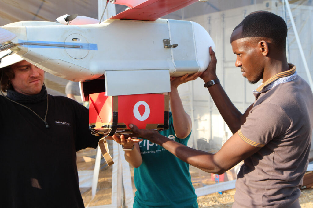
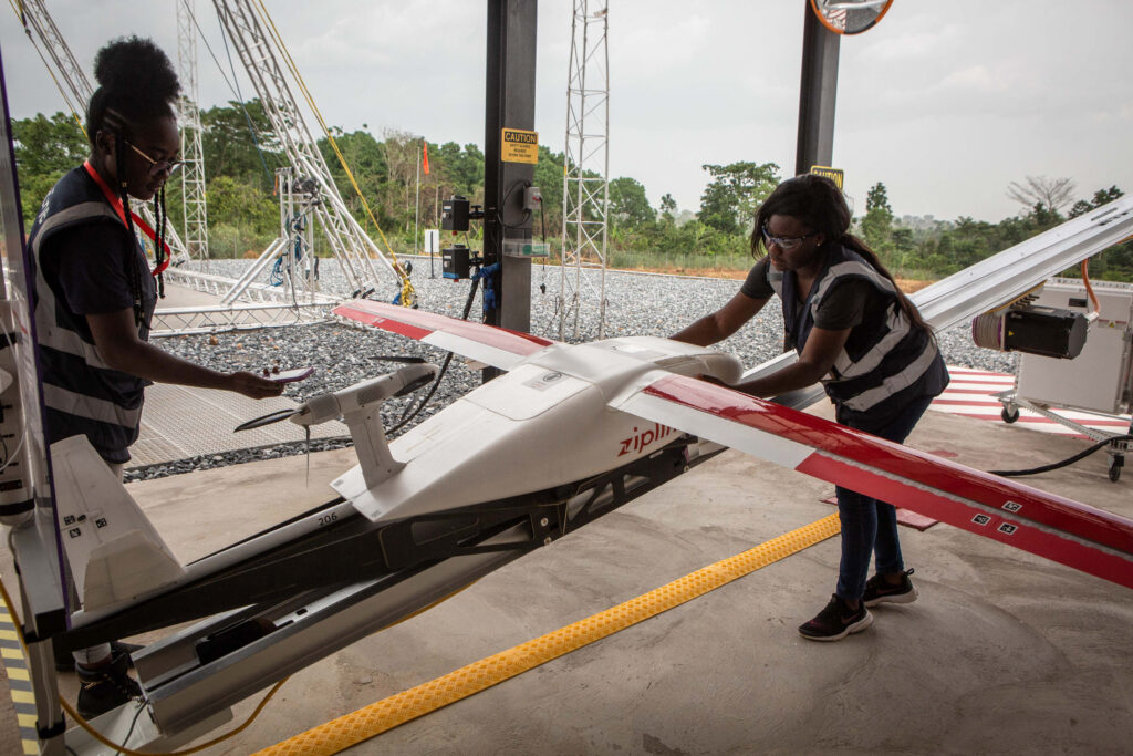
Silicon Valley robotics company Zipline launched the world’s first drone delivery service in Rwanda in 2016, with drones ferrying emergency blood supplies to clinics in hard-to-reach parts of the country.
A study published in medical journal The Lancet in 2022 found Zipline’s drones had more than halved average blood delivery times in Rwanda compared to using road transport. The greatest benefit is felt in hospitals furthest from Kigali. It takes several hours to drive from the capital to Muhororo in the west of the country; a drone takes an average of 29 minutes to complete the delivery. Zipline has since expanded into several other African countries, delivering vaccines and medicines as well as blood supplies. Ghana, however, has struggled to keep-up with its payments to the company, leading to Zipline suspending some of its services there last year.
US support
In November, the US Department of State agreed to provide Zipline $150m “to support the expansion of its life-saving artificial intelligence and robotics infrastructure across Africa”. The deal is under a new “pay-for-performance” model, under which the funds will be released only when African governments sign expansion contracts and commit to ongoing operating costs. Rwanda is expected to be the first country to expand under the new award, with further expansions expected in Côte d’Ivoire, Kenya and Nigeria.
Oliver Defawe, a drone logistics consultant and a former executive at healthcare non-profit VillageReach, sees further potential to expand drone services in the sector.
“I have been a big advocate for over a decade now on the value proposition of cargo drones for increasing access to health and health services, especially for communities that are hard to reach,” he says. Drones are particularly useful for delivering supplies for life-saving emergency responses, he says, adding they can also be the right tool for non-life-saving emergencies and, in some cases, for routine medical deliveries.
“We have demonstrated that cargo drones in specific conditions can reduce the delivery time by hours, sometimes days,” says Defawe. He is particularly excited about technology improvements that enable drones to carry larger cargoes over longer distances. These innovations “will be a game changer for increasing access to health services,” he believes.
Private sector reluctance
Yet Defawe is concerned that drone logistics, both in healthcare and other sectors, is failing to fulfil its potential in Africa due to a lack of private sector investment. “The problem with using cargo drones for solving transportation issues in Africa is not regulatory anymore, it’s not communities, it’s not technology, it’s the business model. It’s economics.”
Defawe stresses that, to succeed in logistics, drone services companies will need to go beyond medical deliveries, and also serve other sectors that can benefit from rapid drone deliveries.
“The biggest drawback is that the market is failing due to a lack of quantitative business models that would attract investors, that would incentivise private companies to start investing into drone transport providers,” he says.
Drones themselves are increasingly cheap – basic light-weight drones can be purchased for a few hundred dollars, and sophisticated cargo drones are generally far cheaper to procure and operate than human-piloted aircraft.
Yet actually running a network of drone operations can be made much more expensive and difficult by the task of meeting extensive licensing and regulatory requirements.
Dexter Tangocci at Integrated Aerial Systems laments the regulatory system for drone companies in South Africa. “It’s quite a complicated and long and expensive process to become a licensed operator in South Africa.”
Getting certified for drone operations took Integrated Aerial Systems two and a half years, he says. Even after the company became a licensed drone operator, Tangocci says, it is still forced to wrestle with “tremendously inefficient” regulatory processes enforced by the South African Civil Aviation Authority.
“It is prohibitively expensive to even just onboard a drone, and it takes it takes a long time, it takes 8-12 weeks to onboard a drone,” he says. “It’s constant work to maintain compliance.”
The drones capital of Africa
The complexity of operating drone services in South Africa opens the door for other countries to lead the continent in harnessing drone technology. Kwamena Hazel at Skyway Aero Group says there is a marked contrast in how Ghana regulates drones compared to South Africa.
“South Africa is very tough with their regulations,” he says. “I think it’s very straightforward in Ghana. The [Ghana Civil Aviation Authority, GCAA] is very open to innovation.”
Hazel says the GCAA has accommodated drone operators that seek to fly UAVs over long distances. Regulators around the world refer to “beyond visual line of sight” (BVLOS) operation and regulate it tightly, due to the possible risks to human-piloted aircraft.
In the UK, for example, the country’s Civil Aviation Authority published a “roadmap” for routine BVLOS as late as October 2025, with an ambition of having routine long-distance flights take place from 2027.
That country is thus lagging behind leading African countries such as Rwanda and Ghana by around a decade.
The emergence of Rwanda and Ghana as early pioneers in BVLOS medical deliveries owes much to the reality that airspace is far less congested in these countries compared to Europe or North America. BVLOS flights have been largely unproblematic since their launch, with no reported incidents involving human-piloted aircraft.
“I always like to say that Ghana is the drone capital of Africa,” says Derrick Annan, CEO of another Ghanaian company, Axis Drone Surveys, which provides aerial intelligence to the mining, agriculture and energy sectors.
Unlike regulators in other African countries, the GCAA has tended to see drones “as an asset, not a weapon,” he adds. “That really helped a lot of the drone companies to grow.”
Meanwhile, Annan says that historically, it was common for aspiring drone pilots to head to the United States or South Africa to gain qualifications in piloting aircraft remotely. However, he says that opportunities for drone operators to train within Ghana are now increasing.
The GCAA’s training arm, Ghana Civil Aviation Training Academy (GATA), accredits training providers in the country. Axis Drone Surveys itself has a small training academy, while more academic institutions are also beginning to offer training programmes. The Kwame Nkrumah University of Science and Technology (KNUST), for example, opened a training academy for operating drones in agriculture last year.
Made in Africa?
Perhaps the final frontier for drone technology in Ghana, and across the rest of the continent, is to scale-up a local drone manufacturing industry. At present drone manufacturing is dominated by Chinese companies. Shenzhen-based DJI is by far the leading supplier of commercial and consumer drones to customers around the world, with a market share of at least 70%.
Commercial drone operators typically purchase off-the-shelf models from DJI, though for more bespoke applications companies sometimes order components from overseas suppliers and assemble models locally.
A more ambitious vision for drone manufacturing in Africa is being put forward by Nigerian company Terra Industries. Its focus is on the security sector; the company has designed and built autonomous drones that it claims are tailored to African operational realities. It already operates a manufacturing facility in Abuja and, following a $34m fundraising round, announced in April that it would open a second manufacturing base in Ghana.
In a statement, Nathan Nwachuku, Terra’s CEO, said: “The only way Africa can have lasting peace is by uniting to build sovereign defence, not by relying on foreign security architecture. We need to control our own destiny by building the tools and systems needed to protect ourselves.”
Whether drone manufacturing can truly take-off in Africa remains to be seen. Especially for civilian drones, it will be difficult for a manufacturer in Africa – or anywhere else in the world – to compete with the economies of scale established by the likes of DJI.
What is not in doubt is that drone technology itself presents a major leapfrogging opportunity for the continent. Drones are well on the way to becoming a vital part of Africa’s economic infrastructure, cutting costs and improving performance across multiple sectors.